
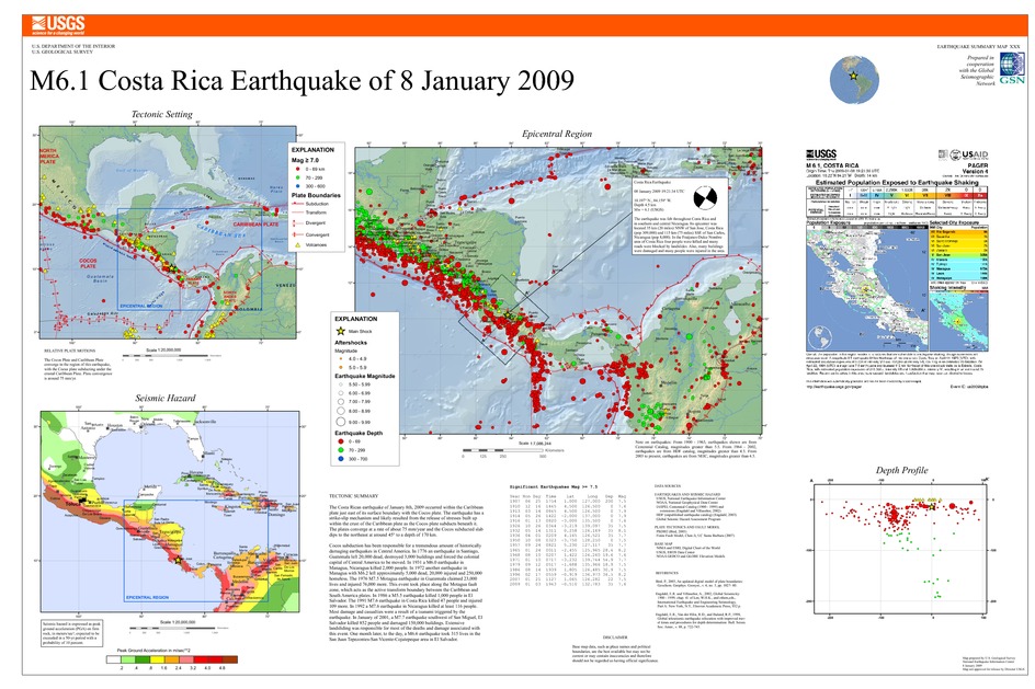
Poster of the Costa Rica Earthquake of 8 January 2009 - Magnitude 6.1
Tectonic Summary
The Costa Rican earthquake of January 8th, 2009 occurred within the Caribbean plate just east of its surface boundary with the Cocos plate. The earthquake has a strike-slip mechanism and likely resulted from the release of stresses built up within the crust of the Caribbean plate as the Cocos plate subducts beneath it. The plates converge at a rate of about 75 mm/year and the Cocos subducted slab dips to the northeast at around 45° to a depth of 170 km.
Cocos subduction has been responsible for a tremendous amount of historically damaging earthquakes in Central America. In 1776 an earthquake in Santiago, Guatemala left 20,000 dead, destroyed 3,000 buildings and forced the colonial capital of Central America to be moved. In 1931 a M6.0 earthquake in Managua, Nicaragua killed 2,000 people. In 1972 another earthquake in Managua with M6.2 left approximately 5,000 dead, 20,000 injured and 250,000 homeless. The 1976 M7.5 Motagua earthquake in Guatemala claimed 23,000 lives and injured 76,000 more. This event took place along the Motagua fault zone, which acts as the active transform boundary between the Caribbean and South America plates. In 1986 a M5.5 earthquake killed 1,000 people in El Salvador. The 1991 M7.6 earthquake in Costa Rica killed 47 people and injured 109 more. In 1992 a M7.6 earthquake in Nicaragua killed at least 116 people. Most damage and casualties were a result of a tsunami triggered by the earthquake. In January of 2001, a M7.7 earthquake southwest of San Miguel, El Salvador killed 852 people and damaged 150,000 buildings. Extensive landsliding was responsible for most of the deaths and damage associated with this event. One month later, to the day, a M6.6 earthquake took 315 lives in the San Juan Tepezontes-San Vicente-Cojutepeque area in El Salvador.
Downloads
Settings
The posters may be downloaded for viewing or for printing on a color
plotter. Adobe PDF (.pdf) format files are provided. Adobe Acrobat 6.0 or
higher is required for viewing the PDF file on a computer monitor and for
printing the PDF map graphic. IMPORTANT: The PDF map graphic was produced
using TrueType fonts; change the following setting to:
Page(Print)Setup<Properties<Layout<Advanced<Graphic<TrueTypeFont<DownloadAsSoftFont
Attention MAC users: If you have problems viewing the pdf files, please download the pdf file and view it in the lastest verion of Adobe Acrobat.
