
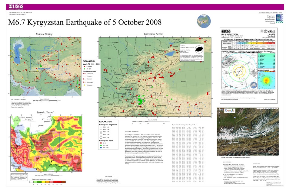
Poster of the Kyrgyzstan Earthquake of 05 October 2008 - Magnitude 6.7
Tectonic Summary
The earthquake of October 5, 2008, occurred as a result of reverse faulting in the region of the Tien Shan and Pamir Mountains, near the intersection of the borders of Kyrgyzstan, Tajikstan, and China. The thrust nature of faulting is inferred from the characteristics of seismic waves radiated by the earthquake source. The faulting that caused the earthquake is a consequence of north-northwest, south-southeast, oriented compressive stress that ultimately arises from the motion of the India plate northwards with respect to the Eurasia plate at a rate of over 40 mm/yr. At the longitude of the earthquake epicenter, the principal boundary between these plates is situated in northern India and Pakistan, approximately 600 km south of the epicenter, but the zone of tectonic deformation associated with their convergence extends to the north of the principal boundary for more than 1000 km.
The tectonics of the epicentral region are complex, and both strike-slip and reverse faulting earthquakes have occurred in the vicinity of the October 5 shock. A magnitude 7.1 earthquake occurred on August 11, 1974, within several tens of kilometers of the 2008 shock; its aftershock sequence included earthquakes generated by both strike-slip and reverse faulting.
Downloads
Settings
The posters may be downloaded for viewing or for printing on a color
plotter. Adobe PDF (.pdf) format files are provided. Adobe Acrobat 6.0 or
higher is required for viewing the PDF file on a computer monitor and for
printing the PDF map graphic. IMPORTANT: The PDF map graphic was produced
using TrueType fonts; change the following setting to:
Page(Print)Setup<Properties<Layout<Advanced<Graphic<TrueTypeFont<DownloadAsSoftFont
Attention MAC users: If you have problems viewing the pdf files, please download the pdf file and view it in the lastest verion of Adobe Acrobat.
