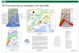
Poster of the Koryakia Earthquake of 20 April 2006 - Magnitude 7.6
Tectonic Summary
The Koryakia earthquake occurred in sparsely populated northeastern Russia, directly north- northeast of the Kamchatka Peninsula. The earthquake was in a complicated geological setting where the configuration and interaction of the tectonic plates between northeastern Asia and northwestern North America are poorly understood. Recent models of the tectonic plates in eastern Russia show that the earthquake occurred near the junction of two plates. These are (1) the Okhotsk plate, which includes the Sea of Okhotsk, the Kamchatka Peninsula and northern Japan, and (2) the extreme northwestern margin of the North American plate. Some evidence indicates that a third plate, the Bering plate, may be present and play a role in the regional tectonics, but this plate is poorly defined with uncertain boundaries.
Geologically, northeastern Russia in the vicinity of the Koryakia earthquake is composed of a sequence of volcanic island arcs that have been attached or accreted to the margin of a continent. In addition, between about 160 and 65 million years ago, sedimentary basins formed in the region and magma intruded the crust and erupted onto it as volcanoes. The boundaries between accreted island arcs are commonly large faults which, under suitable conditions, might be reactivated to cause earthquakes. So many of these old faults formed during the accretion process that it might be difficult to determine which, if any of them broke to cause the Koryakia earthquake.
Current models of plate interactions in northeastern Russia indicate that the region is being squeezed in a southeast- northwest direction, which causes shortening at a rate that might be only a few millimeters per year. This southeast- northwest direction of long- term shortening is consistent with the focal mechanism of the Koryakia earthquake, which shows that shortening produced thrust movement on faults that are oriented in a northeast- southwest direction.
Downloads

Settings
The posters may be downloaded for viewing or for printing on a color
plotter. Adobe PDF (.pdf) format files are provided. Adobe Acrobat 6.0 or
higher is required for viewing the PDF file on a computer monitor and for
printing the PDF map graphic. IMPORTANT: The PDF map graphic was produced
using TrueType fonts; change the following setting to:
Page(Print)Setup<Properties<Layout<Advanced<Graphic<TrueTypeFont<DownloadAsSoftFont
Attention MAC users: If you have problems viewing the pdf files, please download the pdf file and view it in the lastest verion of Adobe Acrobat.

