
Magnitude 4.3 - NEAR SOUTH COAST OF NEW GUINEA, P.N.G.
This webpage is being phased out and is no longer maintained. Please use the new Real-time Earthquake Map instead and update your bookmark. See Quick Tips & User Guide.
2013 January 31 08:27:28 UTC
Earthquake Details
- This event has been reviewed by a seismologist.
| Magnitude | 4.3 |
|---|---|
| Date-Time |
|
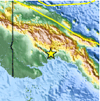
| Location | 7.271°S, 144.084°E |
| Depth | 33.3 km (20.7 miles) |
| Region | NEAR SOUTH COAST OF NEW GUINEA, P.N.G. |
| Distances | 109 km (67 miles) S of Ialibu, Papua New Guinea 129 km (80 miles) SSE of Mendi, Papua New Guinea 156 km (96 miles) S of Mount Hagen, Papua New Guinea 195 km (121 miles) SW of Goroka, Papua New Guinea |
| Location Uncertainty | horizontal +/- 36.3 km (22.6 miles); depth +/- 8.8 km (5.5 miles) |
| Parameters | NST= 20, Nph= 20, Dmin=745.8 km, Rmss=0.77 sec, Gp=140°, M-type=body wave magnitude (Mb), Version=4 |
| Source |
|
| Event ID | usc000ez4g |
- Did you feel it? Report shaking and damage at your location. You can also view a map displaying accumulated data from your report and others.

Earthquake Maps


Scientific & Technical Information
 Historic Moment Tensor Solutions
- Preliminary Earthquake Report
- U.S. Geological Survey, National Earthquake Information Center:
World Data Center for Seismology, Denver
