
Magnitude 5.0 - PHILIPPINE ISLANDS REGION
This webpage is being phased out and is no longer maintained. Please use the new Real-time Earthquake Map instead and update your bookmark. See Quick Tips & User Guide.
2013 January 30 12:57:50 UTC
Earthquake Details
- This event has been reviewed by a seismologist.
| Magnitude | 5.0 |
|---|---|
| Date-Time |
|
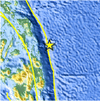
| Location | 10.422°N, 126.922°E |
| Depth | 35 km (21.7 miles) |
| Region | PHILIPPINE ISLANDS REGION |
| Distances | 102 km (63 miles) ENE of San Isidro, Philippines 147 km (91 miles) ESE of Guiuan, Philippines 167 km (103 miles) ENE of Placer, Philippines 168 km (104 miles) NNE of Tandag, Philippines |
| Location Uncertainty | horizontal +/- 20.1 km (12.5 miles); depth +/- 4.4 km (2.7 miles) |
| Parameters | NST=107, Nph=107, Dmin=>999 km, Rmss=1.03 sec, Gp=112°, M-type=body wave magnitude (Mb), Version=8 |
| Source |
|
| Event ID | usc000eybx |
- Did you feel it? Report shaking and damage at your location. You can also view a map displaying accumulated data from your report and others.
Earthquake Maps


Scientific & Technical Information
 Historic Moment Tensor Solutions
 Tsunami Information
The earthquake locations and magnitudes cited in NOAA tsunami statements and bulletins are preliminary and are superseded by USGS locations and magnitudes computed using more extensive data sets.
General Tsunami Information
- Preliminary Earthquake Report
- U.S. Geological Survey, National Earthquake Information Center:
World Data Center for Seismology, Denver
