
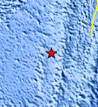
Magnitude 4.6 - SOUTH OF THE FIJI ISLANDS
This webpage is being phased out and is no longer maintained. Please use the new Real-time Earthquake Map instead and update your bookmark. See Quick Tips & User Guide.
2013 January 29 09:03:20 UTC
Earthquake Details
- This event has been reviewed by a seismologist.
| Magnitude | 4.6 |
|---|---|
| Date-Time |
|
| Location | 24.059°S, 179.828°W |
| Depth | 505.1 km (313.9 miles) |
| Region | SOUTH OF THE FIJI ISLANDS |
| Distances | 395 km (245 miles) SSW of Ndoi Island, Fiji 575 km (357 miles) SW of Nuku`alofa, Tonga 679 km (421 miles) SSE of Suva, Fiji 749 km (465 miles) SSE of Nadi, Fiji |
| Location Uncertainty | horizontal +/- 21.7 km (13.5 miles); depth +/- 13.3 km (8.3 miles) |
| Parameters | NST= 44, Nph= 44, Dmin=>999 km, Rmss=0.88 sec, Gp= 97°, M-type=body wave magnitude (Mb), Version=4 |
| Source |
|
| Event ID | usc000exci |
- Did you feel it? Report shaking and damage at your location. You can also view a map displaying accumulated data from your report and others.
Earthquake Maps


Scientific & Technical Information
 Historic Moment Tensor Solutions
- Preliminary Earthquake Report
- U.S. Geological Survey, National Earthquake Information Center:
World Data Center for Seismology, Denver
