
Magnitude 4.7 - BANDA SEA
This webpage is being phased out and is no longer maintained. Please use the new Real-time Earthquake Map instead and update your bookmark. See Quick Tips & User Guide.
2013 January 28 19:33:15 UTC
Earthquake Details
- This event has been reviewed by a seismologist.
| Magnitude | 4.7 |
|---|---|
| Date-Time |
|
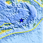
| Location | 6.834°S, 129.006°E |
| Depth | 151.4 km (94.1 miles) |
| Region | BANDA SEA |
| Distances | 283 km (175 miles) WNW of Saumlaki, Indonesia 358 km (222 miles) SSE of Ambon, Indonesia 386 km (239 miles) S of Amahai, Indonesia 424 km (263 miles) ENE of Dili, East Timor |
| Location Uncertainty | horizontal +/- 23.1 km (14.4 miles); depth +/- 24.6 km (15.3 miles) |
| Parameters | NST= 14, Nph= 14, Dmin=282.8 km, Rmss=0.91 sec, Gp=137°, M-type=body wave magnitude (Mb), Version=7 |
| Source |
|
| Event ID | usc000ewur |
- Did you feel it? Report shaking and damage at your location. You can also view a map displaying accumulated data from your report and others.

Earthquake Maps


Scientific & Technical Information
 Historic Moment Tensor Solutions
- Preliminary Earthquake Report
- U.S. Geological Survey, National Earthquake Information Center:
World Data Center for Seismology, Denver
