
Magnitude 4.9 - SANTA CRUZ ISLANDS
This webpage is being phased out and is no longer maintained. Please use the new Real-time Earthquake Map instead and update your bookmark. See Quick Tips & User Guide.
2013 January 28 12:00:17 UTC
Earthquake Details
- This event has been reviewed by a seismologist.
| Magnitude | 4.9 |
|---|---|
| Date-Time |
|
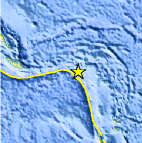
| Location | 11.070°S, 165.368°E |
| Depth | 35 km (21.7 miles) |
| Region | SANTA CRUZ ISLANDS |
| Distances | 63 km (39 miles) SW of Lata, Solomon Islands 530 km (329 miles) NNW of Luganville, Vanuatu 620 km (385 miles) ESE of Honiara, Solomon Islands 803 km (498 miles) NNW of Port-Vila, Vanuatu |
| Location Uncertainty | horizontal +/- 19.7 km (12.2 miles); depth +/- 4.4 km (2.7 miles) |
| Parameters | NST=116, Nph=116, Dmin=621.2 km, Rmss=0.73 sec, Gp=101°, M-type=body wave magnitude (Mb), Version=7 |
| Source |
|
| Event ID | usc000ewmq |
- Did you feel it? Report shaking and damage at your location. You can also view a map displaying accumulated data from your report and others.
Earthquake Maps


Scientific & Technical Information
 Historic Moment Tensor Solutions
- Preliminary Earthquake Report
- U.S. Geological Survey, National Earthquake Information Center:
World Data Center for Seismology, Denver
