
Magnitude 4.6 - TONGA
This webpage is being phased out and is no longer maintained. Please use the new Real-time Earthquake Map instead and update your bookmark. See Quick Tips & User Guide.
2013 January 06 10:20:41 UTC
Earthquake Details
- This event has been reviewed by a seismologist.
| Magnitude | 4.6 |
|---|---|
| Date-Time |
|
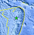
| Location | 17.191°S, 174.157°W |
| Depth | 100.8 km (62.6 miles) |
| Region | TONGA |
| Distances | 144 km (89 miles) SSW of Hihifo, Tonga 449 km (278 miles) NNE of Nuku`alofa, Tonga 451 km (280 miles) SW of Apia, Samoa 485 km (301 miles) SW of Tafuna, American Samoa |
| Location Uncertainty | horizontal +/- 24.1 km (15.0 miles); depth +/- 4 km (2.5 miles) |
| Parameters | NST=120, Nph=121, Dmin=494.3 km, Rmss=0.77 sec, Gp= 68°, M-type=body wave magnitude (Mb), Version=A |
| Source |
|
| Event ID | usc000ek66 |
- Did you feel it? Report shaking and damage at your location. You can also view a map displaying accumulated data from your report and others.
Earthquake Maps


Scientific & Technical Information
 Historic Moment Tensor Solutions
- Preliminary Earthquake Report
- U.S. Geological Survey, National Earthquake Information Center:
World Data Center for Seismology, Denver
