
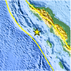
Magnitude 4.8 - SIMEULUE, INDONESIA
This webpage is being phased out and is no longer maintained. Please use the new Real-time Earthquake Map instead and update your bookmark. See Quick Tips & User Guide.
2013 January 01 20:05:03 UTC
Earthquake Details
- This event has been reviewed by a seismologist.
| Magnitude | 4.8 |
|---|---|
| Date-Time |
|
| Location | 2.378°N, 96.175°E |
| Depth | 38.3 km (23.8 miles) |
| Region | SIMEULUE, INDONESIA |
| Distances | 25 km (15 miles) WSW of Sinabang, Indonesia 194 km (120 miles) S of Meulaboh, Indonesia 270 km (167 miles) WSW of Kabanjahe, Indonesia 290 km (180 miles) WSW of Binjai, Indonesia |
| Location Uncertainty | horizontal +/- 20.6 km (12.8 miles); depth +/- 7.1 km (4.4 miles) |
| Parameters | NST= 62, Nph= 63, Dmin=307.2 km, Rmss=0.56 sec, Gp=112°, M-type=body wave magnitude (Mb), Version=6 |
| Source |
|
| Event ID | usc000ei8l |
- Did you feel it? Report shaking and damage at your location. You can also view a map displaying accumulated data from your report and others.

Earthquake Maps


Scientific & Technical Information
 Historic Moment Tensor Solutions
- Preliminary Earthquake Report
- U.S. Geological Survey, National Earthquake Information Center:
World Data Center for Seismology, Denver
