
Magnitude 4.8 - SOUTHEAST OF THE LOYALTY ISLANDS
This webpage is being phased out and is no longer maintained. Please use the new Real-time Earthquake Map instead and update your bookmark. See Quick Tips & User Guide.
2012 November 29 05:41:28 UTC
Earthquake Details
- This event has been reviewed by a seismologist.
| Magnitude | 4.8 |
|---|---|
| Date-Time |
|
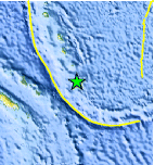
| Location | 21.021°S, 169.996°E |
| Depth | 82.4 km (51.2 miles) |
| Region | SOUTHEAST OF THE LOYALTY ISLANDS |
| Distances | 179 km (111 miles) SSE of Isangel, Vanuatu 284 km (176 miles) E of We, New Caledonia 380 km (236 miles) ENE of Mont-Dore, New Caledonia 388 km (241 miles) ENE of Dumbea, New Caledonia |
| Location Uncertainty | horizontal +/- 21.2 km (13.2 miles); depth +/- 8.9 km (5.5 miles) |
| Parameters | NST= 50, Nph= 55, Dmin=361.8 km, Rmss=0.85 sec, Gp= 86°, M-type=body wave magnitude (Mb), Version=8 |
| Source |
|
| Event ID | usc000e0jj |
- Did you feel it? Report shaking and damage at your location. You can also view a map displaying accumulated data from your report and others.
Earthquake Maps


Scientific & Technical Information
 Historic Moment Tensor Solutions
- Preliminary Earthquake Report
- U.S. Geological Survey, National Earthquake Information Center:
World Data Center for Seismology, Denver
