
Magnitude 4.3 - SERAM, INDONESIA
This webpage is being phased out and is no longer maintained. Please use the new Real-time Earthquake Map instead and update your bookmark. See Quick Tips & User Guide.
2012 November 27 22:08:15 UTC
Earthquake Details
- This event has been reviewed by a seismologist.
| Magnitude | 4.3 |
|---|---|
| Date-Time |
|
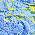
| Location | 3.061°S, 129.138°E |
| Depth | 45.3 km (28.1 miles) |
| Region | SERAM, INDONESIA |
| Distances | 39 km (24 miles) NE of Amahai, Indonesia 127 km (78 miles) ENE of Ambon, Indonesia 336 km (208 miles) SW of Sorong, Indonesia 468 km (290 miles) SSE of Kota Ternate, Indonesia |
| Location Uncertainty | horizontal +/- 18.5 km (11.5 miles); depth +/- 10.4 km (6.5 miles) |
| Parameters | NST= 36, Nph= 38, Dmin=346.2 km, Rmss=1.06 sec, Gp= 65°, M-type=body wave magnitude (Mb), Version=5 |
| Source |
|
| Event ID | usc000dzcg |
- Did you feel it? Report shaking and damage at your location. You can also view a map displaying accumulated data from your report and others.

Earthquake Maps


Scientific & Technical Information
 Historic Moment Tensor Solutions
- Preliminary Earthquake Report
- U.S. Geological Survey, National Earthquake Information Center:
World Data Center for Seismology, Denver
