
Magnitude 4.9 - FIJI REGION
This webpage is being phased out and is no longer maintained. Please use the new Real-time Earthquake Map instead and update your bookmark. See Quick Tips & User Guide.
2012 November 24 18:48:00 UTC
Earthquake Details
- This event has been reviewed by a seismologist.
| Magnitude | 4.9 |
|---|---|
| Date-Time |
|
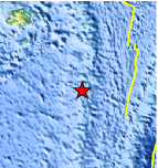
| Location | 21.358°S, 178.808°W |
| Depth | 549.1 km (341.2 miles) |
| Region | FIJI REGION |
| Distances | 79 km (49 miles) S of Ndoi Island, Fiji 375 km (233 miles) W of Nuku`alofa, Tonga 458 km (284 miles) SE of Suva, Fiji 558 km (346 miles) SE of Nadi, Fiji |
| Location Uncertainty | horizontal +/- 16.2 km (10.1 miles); depth +/- 11.1 km (6.9 miles) |
| Parameters | NST=235, Nph=248, Dmin=878.3 km, Rmss=1.07 sec, Gp= 68°, M-type=body wave magnitude (Mb), Version=8 |
| Source |
|
| Event ID | usc000dxrk |
- Did you feel it? Report shaking and damage at your location. You can also view a map displaying accumulated data from your report and others.
Earthquake Maps


Scientific & Technical Information
 Historic Moment Tensor Solutions
- Preliminary Earthquake Report
- U.S. Geological Survey, National Earthquake Information Center:
World Data Center for Seismology, Denver
