
Magnitude 4.8 - NEAR NORTH COAST OF NEW GUINEA, P.N.G.
This webpage is being phased out and is no longer maintained. Please use the new Real-time Earthquake Map instead and update your bookmark. See Quick Tips & User Guide.
2012 November 23 06:21:03 UTC
Earthquake Details
- This event has been reviewed by a seismologist.
| Magnitude | 4.8 |
|---|---|
| Date-Time |
|
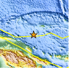
| Location | 3.120°S, 145.897°E |
| Depth | 10.9 km (6.8 miles) |
| Region | NEAR NORTH COAST OF NEW GUINEA, P.N.G. |
| Distances | 194 km (120 miles) SW of Lorengau, Papua New Guinea 233 km (144 miles) N of Madang, Papua New Guinea 257 km (159 miles) E of Wewak, Papua New Guinea 332 km (206 miles) N of Goroka, Papua New Guinea |
| Location Uncertainty | horizontal +/- 30.4 km (18.9 miles); depth +/- 8.8 km (5.5 miles) |
| Parameters | NST= 18, Nph= 18, Dmin=202.6 km, Rmss=1.42 sec, Gp= 94°, M-type=body wave magnitude (Mb), Version=5 |
| Source |
|
| Event ID | usc000dx98 |
- Did you feel it? Report shaking and damage at your location. You can also view a map displaying accumulated data from your report and others.

Earthquake Maps


Scientific & Technical Information
 Historic Moment Tensor Solutions
- Preliminary Earthquake Report
- U.S. Geological Survey, National Earthquake Information Center:
World Data Center for Seismology, Denver
