
Magnitude 4.8 - BOUGAINVILLE REGION, PAPUA NEW GUINEA
This webpage is being phased out and is no longer maintained. Please use the new Real-time Earthquake Map instead and update your bookmark. See Quick Tips & User Guide.
2012 November 21 07:05:50 UTC
Earthquake Details
- This event has been reviewed by a seismologist.
| Magnitude | 4.8 |
|---|---|
| Date-Time |
|
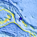
| Location | 5.063°S, 154.425°E |
| Depth | 243.2 km (151.1 miles) |
| Region | BOUGAINVILLE REGION, PAPUA NEW GUINEA |
| Distances | 168 km (104 miles) ESE of Taron, PNG 176 km (109 miles) NW of Arawa, Papua New Guinea 252 km (156 miles) ESE of Kokopo, Papua New Guinea 478 km (297 miles) E of Kimbe, Papua New Guinea |
| Location Uncertainty | horizontal +/- 21.4 km (13.3 miles); depth +/- 11.5 km (7.1 miles) |
| Parameters | NST= 77, Nph= 77, Dmin=>999 km, Rmss=1.14 sec, Gp= 90°, M-type=body wave magnitude (Mb), Version=6 |
| Source |
|
| Event ID | usc000dw1p |
- Did you feel it? Report shaking and damage at your location. You can also view a map displaying accumulated data from your report and others.

Earthquake Maps


Scientific & Technical Information
 Historic Moment Tensor Solutions
- Preliminary Earthquake Report
- U.S. Geological Survey, National Earthquake Information Center:
World Data Center for Seismology, Denver
