
Magnitude 4.8 - NEW BRITAIN REGION, PAPUA NEW GUINEA
This webpage is being phased out and is no longer maintained. Please use the new Real-time Earthquake Map instead and update your bookmark. See Quick Tips & User Guide.
2012 November 19 11:51:18 UTC
Earthquake Details
- This event has been reviewed by a seismologist.
| Magnitude | 4.8 |
|---|---|
| Date-Time |
|
| Location | 5.885°S, 151.871°E |
| Depth | 10.2 km (6.3 miles) |
| Region | NEW BRITAIN REGION, PAPUA NEW GUINEA |
| Distances | 174 km (108 miles) SSW of Kokopo, Papua New Guinea 194 km (120 miles) E of Kimbe, Papua New Guinea 384 km (238 miles) SSE of Kavieng, Papua New Guinea 407 km (252 miles) W of Arawa, Papua New Guinea |
| Location Uncertainty | horizontal +/- 17.2 km (10.7 miles); depth +/- 4.1 km (2.5 miles) |
| Parameters | NST= 35, Nph= 38, Dmin=190.4 km, Rmss=1.23 sec, Gp= 68°, M-type=body wave magnitude (Mb), Version=8 |
| Source |
|
| Event ID | usc000duv3 |
- Did you feel it? Report shaking and damage at your location. You can also view a map displaying accumulated data from your report and others.
Earthquake Maps

Recent Activity At This Location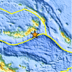
Location Maps
Historical Seismicity
Seismic Hazard Map
Google Map
Google Earth KML
(Requires Google Earth)- Did you feel it? Report shaking and damage at your location. You can also view a map displaying accumulated data from your report and others.
Scientific & Technical Information
 Historic Moment Tensor Solutions
- Preliminary Earthquake Report
- U.S. Geological Survey, National Earthquake Information Center:
World Data Center for Seismology, Denver
