
Magnitude 4.8 - TONGA
This webpage is being phased out and is no longer maintained. Please use the new Real-time Earthquake Map instead and update your bookmark. See Quick Tips & User Guide.
2012 November 15 22:19:09 UTC
Earthquake Details
- This event has been reviewed by a seismologist.
| Magnitude | 4.8 |
|---|---|
| Date-Time |
|
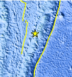
| Location | 20.518°S, 175.116°W |
| Depth | 35.2 km (21.9 miles) |
| Region | TONGA |
| Distances | 68 km (42 miles) N of Nuku`alofa, Tonga 725 km (450 miles) ESE of Suva, Fiji 736 km (457 miles) SE of Lambasa, Fiji 821 km (510 miles) SSW of Apia, Samoa |
| Location Uncertainty | horizontal +/- 28.1 km (17.5 miles); depth +/- 9.7 km (6.0 miles) |
| Parameters | NST= 57, Nph= 57, Dmin=>999 km, Rmss=0.92 sec, Gp=119°, M-type=body wave magnitude (Mb), Version=6 |
| Source |
|
| Event ID | usc000dtcj |
- Did you feel it? Report shaking and damage at your location. You can also view a map displaying accumulated data from your report and others.
Earthquake Maps


Scientific & Technical Information
 Historic Moment Tensor Solutions
- Preliminary Earthquake Report
- U.S. Geological Survey, National Earthquake Information Center:
World Data Center for Seismology, Denver
