
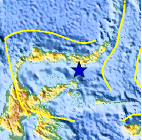
Magnitude 4.7 - SULAWESI, INDONESIA
This webpage is being phased out and is no longer maintained. Please use the new Real-time Earthquake Map instead and update your bookmark. See Quick Tips & User Guide.
2012 November 15 22:10:25 UTC
Earthquake Details
- This event has been reviewed by a seismologist.
| Magnitude | 4.7 |
|---|---|
| Date-Time |
|
| Location | 0.027°S, 123.466°E |
| Depth | 159 km (98.8 miles) |
| Region | SULAWESI, INDONESIA |
| Distances | 53 km (32 miles) SSE of Bilungala, Indonesia 77 km (47 miles) SE of Gorontalo, Indonesia 127 km (78 miles) NE of Luwuk, Indonesia 214 km (132 miles) SW of Tomohon, Indonesia |
| Location Uncertainty | horizontal +/- 15.8 km (9.8 miles); depth +/- 9.3 km (5.8 miles) |
| Parameters | NST= 44, Nph= 46, Dmin=135.8 km, Rmss=0.63 sec, Gp= 54°, M-type=body wave magnitude (Mb), Version=7 |
| Source |
|
| Event ID | usc000dtbz |
- Did you feel it? Report shaking and damage at your location. You can also view a map displaying accumulated data from your report and others.

Earthquake Maps


Scientific & Technical Information
 Historic Moment Tensor Solutions
- Preliminary Earthquake Report
- U.S. Geological Survey, National Earthquake Information Center:
World Data Center for Seismology, Denver
