
Magnitude 4.8 - SOUTH OF THE FIJI ISLANDS
This webpage is being phased out and is no longer maintained. Please use the new Real-time Earthquake Map instead and update your bookmark. See Quick Tips & User Guide.
2012 November 15 15:47:08 UTC
Earthquake Details
- This event has been reviewed by a seismologist.
| Magnitude | 4.8 |
|---|---|
| Date-Time |
|
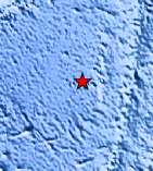
| Location | 25.903°S, 178.294°E |
| Depth | 635.1 km (394.7 miles) |
| Region | SOUTH OF THE FIJI ISLANDS |
| Distances | 529 km (328 miles) NW of Raoul Island, New Zealand 848 km (526 miles) SW of Nuku`alofa, Tonga 859 km (533 miles) S of Suva, Fiji 901 km (559 miles) S of Nadi, Fiji |
| Location Uncertainty | horizontal +/- 18.5 km (11.5 miles); depth +/- 9.2 km (5.7 miles) |
| Parameters | NST=170, Nph=189, Dmin=525.4 km, Rmss=0.94 sec, Gp= 76°, M-type=body wave magnitude (Mb), Version=6 |
| Source |
|
| Event ID | usc000dt13 |
- Did you feel it? Report shaking and damage at your location. You can also view a map displaying accumulated data from your report and others.
Earthquake Maps


Scientific & Technical Information
 Historic Moment Tensor Solutions
- Preliminary Earthquake Report
- U.S. Geological Survey, National Earthquake Information Center:
World Data Center for Seismology, Denver
