
Magnitude 4.8 - NEW BRITAIN REGION, PAPUA NEW GUINEA
This webpage is being phased out and is no longer maintained. Please use the new Real-time Earthquake Map instead and update your bookmark. See Quick Tips & User Guide.
2012 November 15 00:00:06 UTC
Earthquake Details
- This event has been reviewed by a seismologist.
| Magnitude | 4.8 |
|---|---|
| Date-Time |
|
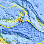
| Location | 5.802°S, 151.723°E |
| Depth | 8.8 km (5.5 miles) |
| Region | NEW BRITAIN REGION, PAPUA NEW GUINEA |
| Distances | 171 km (106 miles) SSW of Kokopo, Papua New Guinea 176 km (109 miles) E of Kimbe, Papua New Guinea 371 km (230 miles) SSE of Kavieng, Papua New Guinea 425 km (264 miles) W of Arawa, Papua New Guinea |
| Location Uncertainty | horizontal +/- 25.8 km (16.0 miles); depth +/- 6.6 km (4.1 miles) |
| Parameters | NST= 42, Nph= 42, Dmin=184.8 km, Rmss=1.37 sec, Gp= 76°, M-type=body wave magnitude (Mb), Version=2 |
| Source |
|
| Event ID | usc000dsu0 |
- Did you feel it? Report shaking and damage at your location. You can also view a map displaying accumulated data from your report and others.

Earthquake Maps


Scientific & Technical Information
 Historic Moment Tensor Solutions
- Preliminary Earthquake Report
- U.S. Geological Survey, National Earthquake Information Center:
World Data Center for Seismology, Denver
