
Magnitude 4.8 - KERMADEC ISLANDS REGION
This webpage is being phased out and is no longer maintained. Please use the new Real-time Earthquake Map instead and update your bookmark. See Quick Tips & User Guide.
2012 November 14 09:15:51 UTC
Earthquake Details
- This event has been reviewed by a seismologist.
| Magnitude | 4.8 |
|---|---|
| Date-Time |
|
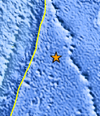
| Location | 30.071°S, 174.541°W |
| Depth | 32.5 km (20.2 miles) |
| Region | KERMADEC ISLANDS REGION |
| Distances | 337 km (209 miles) ESE of Raoul Island, New Zealand 992 km (616 miles) S of Nuku`alofa, Tonga 1172 km (728 miles) NE of Gisborne, New Zealand 1172 km (728 miles) NE of Whakatane, New Zealand |
| Location Uncertainty | horizontal +/- 47.3 km (29.4 miles); depth +/- 9.1 km (5.7 miles) |
| Parameters | NST= 22, Nph= 23, Dmin=>999 km, Rmss=1.42 sec, Gp=202°, M-type=body wave magnitude (Mb), Version=6 |
| Source |
|
| Event ID | usc000dsdj |
- Did you feel it? Report shaking and damage at your location. You can also view a map displaying accumulated data from your report and others.
Earthquake Maps


Scientific & Technical Information
 Historic Moment Tensor Solutions
- Preliminary Earthquake Report
- U.S. Geological Survey, National Earthquake Information Center:
World Data Center for Seismology, Denver
