
Magnitude 4.5 - SUMBAWA REGION, INDONESIA
This webpage is being phased out and is no longer maintained. Please use the new Real-time Earthquake Map instead and update your bookmark. See Quick Tips & User Guide.
2012 November 11 05:24:45 UTC
Earthquake Details
- This event has been reviewed by a seismologist.
| Magnitude | 4.5 |
|---|---|
| Date-Time |
|
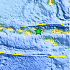
| Location | 8.623°S, 118.366°E |
| Depth | 116.2 km (72.2 miles) |
| Region | SUMBAWA REGION, INDONESIA |
| Distances | 11 km (6 miles) SE of Npongge, Indonesia 41 km (25 miles) WSW of Bima, Indonesia 103 km (64 miles) E of Sumbawa Besar, Indonesia 167 km (103 miles) W of Labuhanbajo, Indonesia |
| Location Uncertainty | horizontal +/- 25.1 km (15.6 miles); depth +/- 20.5 km (12.7 miles) |
| Parameters | NST= 19, Nph= 23, Dmin=426.4 km, Rmss=0.79 sec, Gp= 90°, M-type=body wave magnitude (Mb), Version=5 |
| Source |
|
| Event ID | usc000dqth |
- Did you feel it? Report shaking and damage at your location. You can also view a map displaying accumulated data from your report and others.

Earthquake Maps


Scientific & Technical Information
 Historic Moment Tensor Solutions
- Preliminary Earthquake Report
- U.S. Geological Survey, National Earthquake Information Center:
World Data Center for Seismology, Denver
