
Magnitude 4.7 - VANUATU
This webpage is being phased out and is no longer maintained. Please use the new Real-time Earthquake Map instead and update your bookmark. See Quick Tips & User Guide.
2012 November 10 23:45:49 UTC
Earthquake Details
- This event has been reviewed by a seismologist.
| Magnitude | 4.7 |
|---|---|
| Date-Time |
|
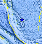
| Location | 18.674°S, 170.179°E |
| Depth | 166 km (103.2 miles) |
| Region | VANUATU |
| Distances | 136 km (84 miles) NE of Isangel, Vanuatu 222 km (137 miles) ESE of Port-Vila, Vanuatu 393 km (244 miles) NE of We, New Caledonia 472 km (293 miles) SE of Luganville, Vanuatu |
| Location Uncertainty | horizontal +/- 24.4 km (15.2 miles); depth +/- 12.7 km (7.9 miles) |
| Parameters | NST= 32, Nph= 32, Dmin=521 km, Rmss=1.28 sec, Gp= 94°, M-type=body wave magnitude (Mb), Version=6 |
| Source |
|
| Event ID | usc000dqpx |
- Did you feel it? Report shaking and damage at your location. You can also view a map displaying accumulated data from your report and others.
Earthquake Maps


Scientific & Technical Information
 Historic Moment Tensor Solutions
- Preliminary Earthquake Report
- U.S. Geological Survey, National Earthquake Information Center:
World Data Center for Seismology, Denver
