
Magnitude 4.5 - SOUTH OF JAVA, INDONESIA
This webpage is being phased out and is no longer maintained. Please use the new Real-time Earthquake Map instead and update your bookmark. See Quick Tips & User Guide.
2012 September 19 07:31:46 UTC
Earthquake Details
- This event has been reviewed by a seismologist.
| Magnitude | 4.5 |
|---|---|
| Date-Time |
|
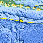
| Location | 10.864°S, 113.891°E |
| Depth | 37.8 km (23.5 miles) |
| Region | SOUTH OF JAVA, INDONESIA |
| Distances | 252 km (156 miles) S of Sidorukun, Indonesia 272 km (169 miles) S of Muncar, Indonesia 274 km (170 miles) S of Gambiran Satu, Indonesia 275 km (170 miles) S of Srono, Indonesia |
| Location Uncertainty | horizontal +/- 43.2 km (26.8 miles); depth +/- 6.1 km (3.8 miles) |
| Parameters | NST= 25, Nph= 28, Dmin=>999 km, Rmss=0.86 sec, Gp=101°, M-type=body wave magnitude (Mb), Version=4 |
| Source |
|
| Event ID | usc000crsk |
- Did you feel it? Report shaking and damage at your location. You can also view a map displaying accumulated data from your report and others.

Earthquake Maps


Scientific & Technical Information
 Historic Moment Tensor Solutions
- Preliminary Earthquake Report
- U.S. Geological Survey, National Earthquake Information Center:
World Data Center for Seismology, Denver
