
Magnitude 4.8 - TONGA
This webpage is being phased out and is no longer maintained. Please use the new Real-time Earthquake Map instead and update your bookmark. See Quick Tips & User Guide.
2012 September 13 21:16:43 UTC
Earthquake Details
- This event has been reviewed by a seismologist.
| Magnitude | 4.8 |
|---|---|
| Date-Time |
|
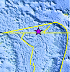
| Location | 15.563°S, 175.610°W |
| Depth | 328.3 km (204.0 miles) |
| Region | TONGA |
| Distances | 203 km (126 miles) WNW of Hihifo, Tonga 455 km (282 miles) WSW of Apia, Samoa 543 km (337 miles) WSW of Tafuna, American Samoa 544 km (338 miles) E of Lambasa, Fiji |
| Location Uncertainty | horizontal +/- 21.5 km (13.4 miles); depth +/- 7.8 km (4.8 miles) |
| Parameters | NST=275, Nph=277, Dmin=452 km, Rmss=0.57 sec, Gp= 90°, M-type=body wave magnitude (Mb), Version=9 |
| Source |
|
| Event ID | usc000cnb5 |
- Did you feel it? Report shaking and damage at your location. You can also view a map displaying accumulated data from your report and others.
Earthquake Maps


Scientific & Technical Information
 Historic Moment Tensor Solutions
- Preliminary Earthquake Report
- U.S. Geological Survey, National Earthquake Information Center:
World Data Center for Seismology, Denver
