
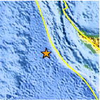
Magnitude 4.9 - OFF THE WEST COAST OF NORTHERN SUMATRA
This webpage is being phased out and is no longer maintained. Please use the new Real-time Earthquake Map instead and update your bookmark. See Quick Tips & User Guide.
2012 September 11 02:24:12 UTC
Earthquake Details
- This event has been reviewed by a seismologist.
| Magnitude | 4.9 |
|---|---|
| Date-Time |
|
| Location | 3.721°N, 92.706°E |
| Depth | 22.5 km (14.0 miles) |
| Region | OFF THE WEST COAST OF NORTHERN SUMATRA |
| Distances | 353 km (219 miles) SW of Banda Aceh, Indonesia 376 km (233 miles) SW of Sabang, Indonesia 382 km (237 miles) W of Meulaboh, Indonesia 405 km (251 miles) WSW of Sigli, Indonesia |
| Location Uncertainty | horizontal +/- 23 km (14.3 miles); depth +/- 6.2 km (3.9 miles) |
| Parameters | NST= 40, Nph= 43, Dmin=604.5 km, Rmss=0.56 sec, Gp= 97°, M-type=body wave magnitude (Mb), Version=8 |
| Source |
|
| Event ID | usc000cl0b |
- Did you feel it? Report shaking and damage at your location. You can also view a map displaying accumulated data from your report and others.
Earthquake Maps


Scientific & Technical Information
 Historic Moment Tensor Solutions
- Preliminary Earthquake Report
- U.S. Geological Survey, National Earthquake Information Center:
World Data Center for Seismology, Denver
