
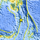
Magnitude 5.1 - KEPULAUAN TALAUD, INDONESIA
This webpage is being phased out and is no longer maintained. Please use the new Real-time Earthquake Map instead and update your bookmark. See Quick Tips & User Guide.
2012 September 10 11:23:29 UTC
Earthquake Details
- This event has been reviewed by a seismologist.
| Magnitude | 5.1 |
|---|---|
| Date-Time |
|
| Location | 3.993°N, 126.189°E |
| Depth | 42.4 km (26.3 miles) |
| Region | KEPULAUAN TALAUD, INDONESIA |
| Distances | 175 km (108 miles) SSE of Sarangani, Philippines 221 km (137 miles) SSE of Caburan, Philippines 230 km (142 miles) SSE of Glan, Philippines 240 km (149 miles) SSE of Malapatan, Philippines |
| Location Uncertainty | horizontal +/- 17.5 km (10.9 miles); depth +/- 4.6 km (2.9 miles) |
| Parameters | NST= 68, Nph= 73, Dmin=347.3 km, Rmss=0.9 sec, Gp= 76°, M-type=body wave magnitude (Mb), Version=6 |
| Source |
|
| Event ID | usc000ck6q |
- Did you feel it? Report shaking and damage at your location. You can also view a map displaying accumulated data from your report and others.

Earthquake Maps


Scientific & Technical Information
 Historic Moment Tensor Solutions
 Tsunami Information
The earthquake locations and magnitudes cited in NOAA tsunami statements and bulletins are preliminary and are superseded by USGS locations and magnitudes computed using more extensive data sets.
General Tsunami Information
- Preliminary Earthquake Report
- U.S. Geological Survey, National Earthquake Information Center:
World Data Center for Seismology, Denver
