
Magnitude 3.2 - NEAR THE SOUTHEAST COAST OF AUSTRALIA
This webpage is being phased out and is no longer maintained. Please use the new Real-time Earthquake Map instead and update your bookmark. See Quick Tips & User Guide.
2012 September 10 06:23:51 UTC
Earthquake Details
- This event has been reviewed by a seismologist.
| Magnitude | 3.2 |
|---|---|
| Date-Time |
|
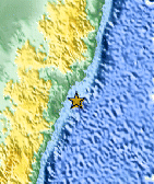
| Location | 33.487°S, 151.950°E |
| Depth | 0 km (~0 mile) (poorly constrained) |
| Region | NEAR THE SOUTHEAST COAST OF AUSTRALIA |
| Distances | 52 km (32 miles) E of Hawks Nest, Australia 61 km (37 miles) E of Port Stephens, Australia 65 km (40 miles) SSE of Forster, Australia 90 km (55 miles) E of Raymond Terrace, Australia |
| Location Uncertainty | horizontal +/- 18.8 km (11.7 miles); depth +/- 10.4 km (6.5 miles) |
| Parameters | Nph= 0, Dmin=0 km, Rmss=2.39 sec, Gp= 0, M-type=local magnitude (ML), Version=7 |
| Source |
|
| Event ID | usc000ck40 |
- Did you feel it? Report shaking and damage at your location. You can also view a map displaying accumulated data from your report and others.

Earthquake Maps


Scientific & Technical Information
- Preliminary Earthquake Report
- U.S. Geological Survey, National Earthquake Information Center:
World Data Center for Seismology, Denver
