
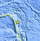
Magnitude 4.8 - SANTA CRUZ ISLANDS
This webpage is being phased out and is no longer maintained. Please use the new Real-time Earthquake Map instead and update your bookmark. See Quick Tips & User Guide.
2012 September 05 05:32:11 UTC
Earthquake Details
- This event has been reviewed by a seismologist.
| Magnitude | 4.8 |
|---|---|
| Date-Time |
|
| Location | 12.377°S, 166.515°E |
| Depth | 49.9 km (31.0 miles) |
| Region | SANTA CRUZ ISLANDS |
| Distances | 198 km (123 miles) SSE of Lata, Solomon Islands 356 km (221 miles) NNW of Luganville, Vanuatu 623 km (387 miles) NNW of Port-Vila, Vanuatu 787 km (489 miles) ESE of Honiara, Solomon Islands |
| Location Uncertainty | horizontal +/- 17.3 km (10.7 miles); depth +/- 11.2 km (7.0 miles) |
| Parameters | NST= 19, Nph= 23, Dmin=788.1 km, Rmss=0.56 sec, Gp=108°, M-type=body wave magnitude (Mb), Version=4 |
| Source |
|
| Event ID | usc000cflb |
- Did you feel it? Report shaking and damage at your location. You can also view a map displaying accumulated data from your report and others.
Earthquake Maps


Scientific & Technical Information
 Historic Moment Tensor Solutions
- Preliminary Earthquake Report
- U.S. Geological Survey, National Earthquake Information Center:
World Data Center for Seismology, Denver
