
Magnitude 5.6 - MINDANAO, PHILIPPINES
This webpage is being phased out and is no longer maintained. Please use the new Real-time Earthquake Map instead and update your bookmark. See Quick Tips & User Guide.
2012 September 03 19:44:22 UTC
Earthquake Details
- This event has been reviewed by a seismologist.
| Magnitude | 5.6 |
|---|---|
| Date-Time |
|
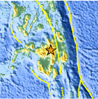
| Location | 7.946°N, 125.118°E |
| Depth | 9.8 km (6.1 miles) |
| Region | MINDANAO, PHILIPPINES |
| Distances | 2 km (1 miles) SW of Mailag, Philippines 5 km (3 miles) NNE of Valencia, Philippines 14 km (8 miles) NE of Dologon, Philippines 20 km (12 miles) S of Casisang, Philippines |
| Location Uncertainty | horizontal +/- 13.3 km (8.3 miles); depth +/- 4.2 km (2.6 miles) |
| Parameters | NST=142, Nph=142, Dmin=109.1 km, Rmss=1.06 sec, Gp= 25°, M-type=body wave magnitude (Mb), Version=7 |
| Source |
|
| Event ID | usc000ce66 |
- Did you feel it? Report shaking and damage at your location. You can also view a map displaying accumulated data from your report and others.

Earthquake Maps


Scientific & Technical Information

- Preliminary Earthquake Report
- U.S. Geological Survey, National Earthquake Information Center:
World Data Center for Seismology, Denver
