
Magnitude 4.5 - SOUTH OF THE FIJI ISLANDS
This webpage has been replaced by a new version and will be phased out in the future. Please use our new Real-time Earthquake Map to access the latest earthquake information and event details. The links to the World, US, and CA/NV maps that were in the navigation on the left side of the page have been replaced by the links at the top of the new Map. The Real-time Earthquake Map User Guide describes how to use the map and all its features.
2012 May 01 05:58:51 UTC
Earthquake Details
- This event has been reviewed by a seismologist.
| Magnitude | 4.5 |
|---|---|
| Date-Time |
|
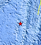
| Location | 24.301°S, 179.960°E |
| Depth | 505.9 km (314.4 miles) |
| Region | SOUTH OF THE FIJI ISLANDS |
| Distances | 427 km (265 miles) SSW of Ndoi Island, Fiji 590 km (366 miles) NNW of Raoul Island, Kermadec Islands 608 km (377 miles) SW of NUKU`ALOFA, Tonga 1479 km (919 miles) NNE of Auckland, New Zealand |
| Location Uncertainty | horizontal +/- 47.8 km (29.7 miles); depth +/- 14.6 km (9.1 miles) |
| Parameters | NST= 38, Nph= 38, Dmin=752.5 km, Rmss=0.91 sec, Gp=191°, M-type=body wave magnitude (Mb), Version=5 |
| Source |
|
| Event ID | usc0009fz1 |
- Did you feel it? Report shaking and damage at your location. You can also view a map displaying accumulated data from your report and others.
Earthquake Maps


Scientific & Technical Information
 Historic Moment Tensor Solutions
- Preliminary Earthquake Report
- U.S. Geological Survey, National Earthquake Information Center:
World Data Center for Seismology, Denver
