
Magnitude 4.9 - NEW BRITAIN REGION, PAPUA NEW GUINEA
2012 January 31 18:25:11 UTC
Earthquake Details
- This event has been reviewed by a seismologist.
| Magnitude | 4.9 |
|---|---|
| Date-Time |
|
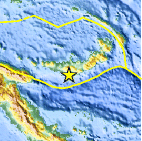
| Location | 6.309°S, 149.891°E |
| Depth | 43.3 km (26.9 miles) |
| Region | NEW BRITAIN REGION, PAPUA NEW GUINEA |
| Distances | 39 km (24 miles) ESE of Kandrian, New Britain, PNG 88 km (54 miles) SSW of Kimbe, New Britain, PNG 458 km (284 miles) NE of PORT MORESBY, Papua New Guinea 2368 km (1471 miles) N of BRISBANE, Queensland, Australia |
| Location Uncertainty | horizontal +/- 15.7 km (9.8 miles); depth +/- 9.4 km (5.8 miles) |
| Parameters | NST= 47, Nph= 47, Dmin=344 km, Rmss=1.25 sec, Gp= 40°, M-type=body wave magnitude (Mb), Version=7 |
| Source |
|
| Event ID | usc0007uie |
- Did you feel it? Report shaking and damage at your location. You can also view a map displaying accumulated data from your report and others.

Earthquake Maps


Scientific & Technical Information
 Historic Moment Tensor Solutions
- Preliminary Earthquake Report
- U.S. Geological Survey, National Earthquake Information Center:
World Data Center for Seismology, Denver
