
Magnitude 4.8 - LEYTE, PHILIPPINES
2012 January 29 06:01:48 UTC
Earthquake Details
- This event has been reviewed by a seismologist.
| Magnitude | 4.8 |
|---|---|
| Date-Time |
|
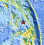
| Location | 10.095°N, 124.203°E |
| Depth | 580.1 km (360.5 miles) |
| Region | LEYTE, PHILIPPINES |
| Distances | 39 km (24 miles) SE of Cebu, Cebu, Philippines 62 km (38 miles) NE of Tagbilaran, Bohol, Philippines 131 km (81 miles) NE of Dumaguete, Negros, Philippines 609 km (378 miles) SE of MANILA, Philippines |
| Location Uncertainty | horizontal +/- 19.1 km (11.9 miles); depth +/- 12.2 km (7.6 miles) |
| Parameters | NST= 95, Nph= 96, Dmin=831.6 km, Rmss=0.91 sec, Gp= 83°, M-type=body wave magnitude (Mb), Version=6 |
| Source |
|
| Event ID | usc0007t5d |
- Did you feel it? Report shaking and damage at your location. You can also view a map displaying accumulated data from your report and others.

Earthquake Maps


Scientific & Technical Information
 Historic Moment Tensor Solutions
- Preliminary Earthquake Report
- U.S. Geological Survey, National Earthquake Information Center:
World Data Center for Seismology, Denver
