
Magnitude 5.2 - MINDANAO, PHILIPPINES
2012 January 29 00:06:51 UTC
Earthquake Details
- This event has been reviewed by a seismologist.
| Magnitude | 5.2 |
|---|---|
| Date-Time |
|
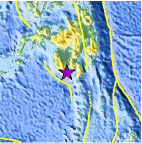
| Location | 5.952°N, 124.771°E |
| Depth | 384.4 km (238.9 miles) |
| Region | MINDANAO, PHILIPPINES |
| Distances | 48 km (29 miles) WSW of General Santos, Mindanao, Philippines 152 km (94 miles) SSE of Cotabato, Mindanao, Philippines 155 km (96 miles) SW of Davao, Mindanao, Philippines 1043 km (648 miles) SSE of MANILA, Philippines |
| Location Uncertainty | horizontal +/- 13.5 km (8.4 miles); depth +/- 9.3 km (5.8 miles) |
| Parameters | NST=142, Nph=155, Dmin=152.5 km, Rmss=0.84 sec, Gp= 36°, M-type=body wave magnitude (Mb), Version=7 |
| Source |
|
| Event ID | usc0007t3h |
- Did you feel it? Report shaking and damage at your location. You can also view a map displaying accumulated data from your report and others.

Earthquake Maps


Scientific & Technical Information
 Historic Moment Tensor Solutions
- Preliminary Earthquake Report
- U.S. Geological Survey, National Earthquake Information Center:
World Data Center for Seismology, Denver
