
Magnitude 4.5 - SOUTH ISLAND OF NEW ZEALAND
2012 January 28 22:56:11 UTC
Earthquake Details
- This event has been reviewed by a seismologist.
| Magnitude | 4.5 |
|---|---|
| Date-Time |
|
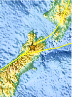
| Location | 42.010°S, 172.580°E |
| Depth | 9 km (5.6 miles) (poorly constrained) |
| Region | SOUTH ISLAND OF NEW ZEALAND |
| Distances | 86 km (53 miles) ESE of Westport, New Zealand 171 km (106 miles) N of Christchurch, New Zealand 200 km (124 miles) WSW of WELLINGTON, New Zealand 314 km (195 miles) SW of Palmerston North, New Zealand |
| Location Uncertainty | horizontal +/- 15.4 km (9.6 miles); depth +/- 11.6 km (7.2 miles) |
| Parameters | Nph= 0, Dmin=0 km, Rmss=0.5 sec, Gp= 0, M-type=local magnitude (ML), Version=5 |
| Source |
|
| Event ID | usc0007t2i |
- Did you feel it? Report shaking and damage at your location. You can also view a map displaying accumulated data from your report and others.

Earthquake Maps


Scientific & Technical Information
 Historic Moment Tensor Solutions
Additional Information
- Preliminary Earthquake Report
- U.S. Geological Survey, National Earthquake Information Center:
World Data Center for Seismology, Denver
