
Magnitude 4.7 - KERMADEC ISLANDS REGION
2012 January 28 04:56:15 UTC
Earthquake Details
- This event has been reviewed by a seismologist.
| Magnitude | 4.7 |
|---|---|
| Date-Time |
|
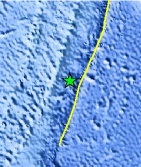
| Location | 31.965°S, 178.047°W |
| Depth | 149.4 km (92.8 miles) |
| Region | KERMADEC ISLANDS REGION |
| Distances | 99 km (61 miles) SE of L'Esperance Rock, Kermadec Islands 298 km (185 miles) S of Raoul Island, Kermadec Islands 855 km (531 miles) NE of Auckland, New Zealand 1217 km (756 miles) NE of WELLINGTON, New Zealand |
| Location Uncertainty | horizontal +/- 84.6 km (52.6 miles); depth +/- 57.1 km (35.5 miles) |
| Parameters | NST= 22, Nph= 25, Dmin=301.7 km, Rmss=1.25 sec, Gp=137°, M-type=body wave magnitude (Mb), Version=6 |
| Source |
|
| Event ID | usc0007ss2 |
- Did you feel it? Report shaking and damage at your location. You can also view a map displaying accumulated data from your report and others.
Earthquake Maps


Scientific & Technical Information
 Historic Moment Tensor Solutions
- Preliminary Earthquake Report
- U.S. Geological Survey, National Earthquake Information Center:
World Data Center for Seismology, Denver
