
Magnitude 4.9 - BABUYAN ISLANDS REGION, PHILIPPINES
2012 January 28 04:46:22 UTC
Earthquake Details
- This event has been reviewed by a seismologist.
| Magnitude | 4.9 |
|---|---|
| Date-Time |
|
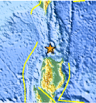
| Location | 19.266°N, 121.160°E |
| Depth | 9.1 km (5.7 miles) |
| Region | BABUYAN ISLANDS REGION, PHILIPPINES |
| Distances | 132 km (82 miles) NNE of Laoag, Luzon, Philippines 154 km (95 miles) SSW of Basco, Batan Islands, Philippines 247 km (153 miles) NNW of Ilagan, Luzon, Philippines 516 km (320 miles) N of MANILA, Philippines |
| Location Uncertainty | horizontal +/- 15.3 km (9.5 miles); depth +/- 4 km (2.5 miles) |
| Parameters | NST= 96, Nph= 99, Dmin=393 km, Rmss=1.21 sec, Gp= 58°, M-type=body wave magnitude (Mb), Version=7 |
| Source |
|
| Event ID | usc0007srx |
- Did you feel it? Report shaking and damage at your location. You can also view a map displaying accumulated data from your report and others.

Earthquake Maps


Scientific & Technical Information
 Historic Moment Tensor Solutions
- Preliminary Earthquake Report
- U.S. Geological Survey, National Earthquake Information Center:
World Data Center for Seismology, Denver
