
Magnitude 4.7 - SERAM, INDONESIA
2012 January 26 23:04:19 UTC
Earthquake Details
- This event has been reviewed by a seismologist.
| Magnitude | 4.7 |
|---|---|
| Date-Time |
|
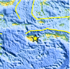
| Location | 3.466°S, 127.043°E |
| Depth | 66.5 km (41.3 miles) |
| Region | SERAM, INDONESIA |
| Distances | 129 km (80 miles) WNW of Ambon, Moluccas, Indonesia 471 km (292 miles) S of Ternate, Moluccas, Indonesia 1079 km (670 miles) NNW of DARWIN, Northern Territory, Australia 2262 km (1405 miles) E of JAKARTA, Java, Indonesia |
| Location Uncertainty | horizontal +/- 17.1 km (10.6 miles); depth +/- 9.8 km (6.1 miles) |
| Parameters | NST= 34, Nph= 34, Dmin=582.2 km, Rmss=0.62 sec, Gp= 76°, M-type=body wave magnitude (Mb), Version=5 |
| Source |
|
| Event ID | usc0007s7w |
- Did you feel it? Report shaking and damage at your location. You can also view a map displaying accumulated data from your report and others.

Earthquake Maps


Scientific & Technical Information
 Historic Moment Tensor Solutions
- Preliminary Earthquake Report
- U.S. Geological Survey, National Earthquake Information Center:
World Data Center for Seismology, Denver
