
Magnitude 4.6 - MINAHASA, SULAWESI, INDONESIA
2012 January 26 11:44:55 UTC
Earthquake Details
- This event has been reviewed by a seismologist.
| Magnitude | 4.6 |
|---|---|
| Date-Time |
|
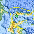
| Location | 0.232°N, 120.914°E |
| Depth | 136.1 km (84.6 miles) |
| Region | MINAHASA, SULAWESI, INDONESIA |
| Distances | 138 km (85 miles) ESE of Palu, Sulawesi, Indonesia 242 km (150 miles) W of Gorontalo, Sulawesi, Indonesia 843 km (523 miles) SE of BANDAR SERI BEGAWAN, Brunei 1590 km (987 miles) S of MANILA, Philippines |
| Location Uncertainty | horizontal +/- 36.9 km (22.9 miles); depth +/- 6.3 km (3.9 miles) |
| Parameters | NST= 21, Nph= 22, Dmin=250.5 km, Rmss=0.86 sec, Gp=130°, M-type=body wave magnitude (Mb), Version=5 |
| Source |
|
| Event ID | usc0007rvu |
- Did you feel it? Report shaking and damage at your location. You can also view a map displaying accumulated data from your report and others.

Earthquake Maps


Scientific & Technical Information
 Historic Moment Tensor Solutions
- Preliminary Earthquake Report
- U.S. Geological Survey, National Earthquake Information Center:
World Data Center for Seismology, Denver
