
Magnitude 4.4 - CERAM SEA, INDONESIA
2012 January 25 09:03:41 UTC
Earthquake Details
- This event has been reviewed by a seismologist.
| Magnitude | 4.4 |
|---|---|
| Date-Time |
|
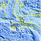
| Location | 2.004°S, 128.349°E |
| Depth | 39 km (24.2 miles) |
| Region | CERAM SEA, INDONESIA |
| Distances | 188 km (116 miles) N of Ambon, Moluccas, Indonesia 325 km (201 miles) SSE of Ternate, Moluccas, Indonesia 787 km (489 miles) NNE of DILI, Timor-Leste 1190 km (739 miles) NNW of DARWIN, Northern Territory, Australia |
| Location Uncertainty | horizontal +/- 22 km (13.7 miles); depth +/- 12 km (7.5 miles) |
| Parameters | NST= 14, Nph= 17, Dmin=326.2 km, Rmss=0.83 sec, Gp=112°, M-type=body wave magnitude (Mb), Version=5 |
| Source |
|
| Event ID | usc0007rb9 |
- Did you feel it? Report shaking and damage at your location. You can also view a map displaying accumulated data from your report and others.

Earthquake Maps


Scientific & Technical Information
 Historic Moment Tensor Solutions
- Preliminary Earthquake Report
- U.S. Geological Survey, National Earthquake Information Center:
World Data Center for Seismology, Denver
