
Magnitude 5.1 - OFF WEST COAST OF THE SOUTH ISLAND, N.Z.
2012 January 25 06:02:31 UTC
Earthquake Details
- This event has been reviewed by a seismologist.
| Magnitude | 5.1 |
|---|---|
| Date-Time |
|
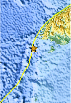
| Location | 46.940°S, 165.765°E |
| Depth | 9.7 km (6.0 miles) |
| Region | OFF WEST COAST OF THE SOUTH ISLAND, N.Z. |
| Distances | 206 km (128 miles) WSW of Invercargill, New Zealand 308 km (191 miles) SW of Queenstown, New Zealand 383 km (237 miles) WSW of Dunedin, New Zealand 954 km (592 miles) SW of WELLINGTON, New Zealand |
| Location Uncertainty | horizontal +/- 22.1 km (13.7 miles); depth +/- 2.9 km (1.8 miles) |
| Parameters | NST= 37, Nph= 39, Dmin=111.3 km, Rmss=1.27 sec, Gp=140°, M-type=body wave magnitude (Mb), Version=8 |
| Source |
|
| Event ID | usc0007r94 |
- Did you feel it? Report shaking and damage at your location. You can also view a map displaying accumulated data from your report and others.
Earthquake Maps


Scientific & Technical Information
 Historic Moment Tensor Solutions
 Tsunami Information
The earthquake locations and magnitudes cited in NOAA tsunami statements and bulletins are preliminary and are superseded by USGS locations and magnitudes computed using more extensive data sets.
General Tsunami Information
- Preliminary Earthquake Report
- U.S. Geological Survey, National Earthquake Information Center:
World Data Center for Seismology, Denver
