
Magnitude 4.7 - SOUTHERN SUMATRA, INDONESIA
2012 January 23 23:41:08 UTC
Earthquake Details
- This event has been reviewed by a seismologist.
| Magnitude | 4.7 |
|---|---|
| Date-Time |
|
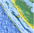
| Location | 1.975°S, 100.265°E |
| Depth | 53 km (32.9 miles) |
| Region | SOUTHERN SUMATRA, INDONESIA |
| Distances | 113 km (70 miles) S of Padang, Sumatra, Indonesia 300 km (186 miles) NW of Bengkulu, Sumatra, Indonesia 538 km (334 miles) SW of SINGAPORE 864 km (536 miles) WNW of JAKARTA, Java, Indonesia |
| Location Uncertainty | horizontal +/- 32.4 km (20.1 miles); depth +/- 14.8 km (9.2 miles) |
| Parameters | NST= 14, Nph= 14, Dmin=268.3 km, Rmss=0.44 sec, Gp=202°, M-type=body wave magnitude (Mb), Version=6 |
| Source |
|
| Event ID | usc0007qq5 |
- Did you feel it? Report shaking and damage at your location. You can also view a map displaying accumulated data from your report and others.

Earthquake Maps


Scientific & Technical Information
 Historic Moment Tensor Solutions
- Preliminary Earthquake Report
- U.S. Geological Survey, National Earthquake Information Center:
World Data Center for Seismology, Denver
