
Magnitude 4.3 - SERAM, INDONESIA
2012 January 22 23:41:00 UTC
Earthquake Details
- This event has been reviewed by a seismologist.
| Magnitude | 4.3 |
|---|---|
| Date-Time |
|
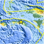
| Location | 3.010°S, 129.826°E |
| Depth | 43.7 km (27.2 miles) |
| Region | SERAM, INDONESIA |
| Distances | 198 km (123 miles) ENE of Ambon, Moluccas, Indonesia 283 km (175 miles) SSW of Sorong, Papua, Indonesia 1052 km (653 miles) N of DARWIN, Northern Territory, Australia 2576 km (1600 miles) E of JAKARTA, Java, Indonesia |
| Location Uncertainty | horizontal +/- 20.9 km (13.0 miles); depth +/- 14.3 km (8.9 miles) |
| Parameters | NST= 23, Nph= 25, Dmin=269.4 km, Rmss=0.26 sec, Gp= 54°, M-type=body wave magnitude (Mb), Version=5 |
| Source |
|
| Event ID | usc0007qdl |
- Did you feel it? Report shaking and damage at your location. You can also view a map displaying accumulated data from your report and others.

Earthquake Maps


Scientific & Technical Information
 Historic Moment Tensor Solutions
- Preliminary Earthquake Report
- U.S. Geological Survey, National Earthquake Information Center:
World Data Center for Seismology, Denver
