
Magnitude 4.6 - SAMAR, PHILIPPINES
2012 January 22 06:41:28 UTC
Earthquake Details
- This event has been reviewed by a seismologist.
| Magnitude | 4.6 |
|---|---|
| Date-Time |
|
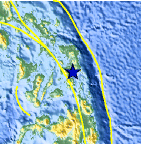
| Location | 11.038°N, 125.114°E |
| Depth | 165.8 km (103.0 miles) |
| Region | SAMAR, PHILIPPINES |
| Distances | 25 km (15 miles) SSE of Tacloban, Leyte, Philippines 67 km (41 miles) W of Guiuan, Samar, Philippines 126 km (78 miles) SSE of Calbayog, Samar, Philippines 596 km (370 miles) SE of MANILA, Philippines |
| Location Uncertainty | horizontal +/- 24 km (14.9 miles); depth +/- 11.5 km (7.1 miles) |
| Parameters | NST= 36, Nph= 37, Dmin=441.9 km, Rmss=0.53 sec, Gp=126°, M-type=body wave magnitude (Mb), Version=5 |
| Source |
|
| Event ID | usc0007px8 |
- Did you feel it? Report shaking and damage at your location. You can also view a map displaying accumulated data from your report and others.

Earthquake Maps


Scientific & Technical Information
 Historic Moment Tensor Solutions
- Preliminary Earthquake Report
- U.S. Geological Survey, National Earthquake Information Center:
World Data Center for Seismology, Denver
