
Magnitude 4.4 - SERAM, INDONESIA
2012 January 22 01:00:24 UTC
Earthquake Details
- This event has been reviewed by a seismologist.
| Magnitude | 4.4 |
|---|---|
| Date-Time |
|
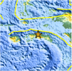
| Location | 2.899°S, 129.234°E |
| Depth | 27.4 km (17.0 miles) |
| Region | SERAM, INDONESIA |
| Distances | 146 km (90 miles) NE of Ambon, Moluccas, Indonesia 316 km (196 miles) SW of Sorong, Papua, Indonesia 745 km (462 miles) NNE of DILI, Timor-Leste 1073 km (666 miles) N of DARWIN, Northern Territory, Australia |
| Location Uncertainty | horizontal +/- 24.9 km (15.5 miles); depth +/- 10.9 km (6.8 miles) |
| Parameters | NST= 17, Nph= 18, Dmin=335.1 km, Rmss=0.83 sec, Gp=119°, M-type=body wave magnitude (Mb), Version=5 |
| Source |
|
| Event ID | usc0007pue |
- Did you feel it? Report shaking and damage at your location. You can also view a map displaying accumulated data from your report and others.

Earthquake Maps


Scientific & Technical Information
 Historic Moment Tensor Solutions
- Preliminary Earthquake Report
- U.S. Geological Survey, National Earthquake Information Center:
World Data Center for Seismology, Denver
