
Magnitude 4.6 - MINDANAO, PHILIPPINES
2012 January 21 18:29:56 UTC
Earthquake Details
- This event has been reviewed by a seismologist.
| Magnitude | 4.6 |
|---|---|
| Date-Time |
|
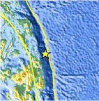
| Location | 9.743°N, 126.618°E |
| Depth | 37.6 km (23.4 miles) |
| Region | MINDANAO, PHILIPPINES |
| Distances | 124 km (77 miles) E of Surigao, Mindanao, Philippines 147 km (91 miles) NE of Butuan, Mindanao, Philippines 154 km (95 miles) NNE of Hinatuan, Mindanao, Philippines 815 km (506 miles) SE of MANILA, Philippines |
| Location Uncertainty | horizontal +/- 29.1 km (18.1 miles); depth +/- 14.5 km (9.0 miles) |
| Parameters | NST= 28, Nph= 28, Dmin=317.3 km, Rmss=0.68 sec, Gp=155°, M-type=body wave magnitude (Mb), Version=5 |
| Source |
|
| Event ID | usc0007pnf |
- Did you feel it? Report shaking and damage at your location. You can also view a map displaying accumulated data from your report and others.

Earthquake Maps


Scientific & Technical Information
 Historic Moment Tensor Solutions
- Preliminary Earthquake Report
- U.S. Geological Survey, National Earthquake Information Center:
World Data Center for Seismology, Denver
