
Magnitude 5.3 - KEPULAUAN SANGIHE, INDONESIA
2012 January 20 22:50:53 UTC
Earthquake Details
- This event has been reviewed by a seismologist.
| Magnitude | 5.3 |
|---|---|
| Date-Time |
|
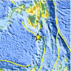
| Location | 4.808°N, 125.306°E |
| Depth | 59 km (36.7 miles) |
| Region | KEPULAUAN SANGIHE, INDONESIA |
| Distances | 144 km (89 miles) S of General Santos, Mindanao, Philippines 252 km (156 miles) S of Davao, Mindanao, Philippines 1054 km (654 miles) WSW of KOROR, Palau 1183 km (735 miles) SSE of MANILA, Philippines |
| Location Uncertainty | horizontal +/- 13.5 km (8.4 miles); depth +/- 8.6 km (5.3 miles) |
| Parameters | NST=101, Nph=101, Dmin=251.6 km, Rmss=0.7 sec, Gp= 36°, M-type=body wave magnitude (Mb), Version=5 |
| Source |
|
| Event ID | usc0007pfx |
- Did you feel it? Report shaking and damage at your location. You can also view a map displaying accumulated data from your report and others.

Earthquake Maps


Scientific & Technical Information

 Tsunami Information
The earthquake locations and magnitudes cited in NOAA tsunami statements and bulletins are preliminary and are superseded by USGS locations and magnitudes computed using more extensive data sets.
General Tsunami Information
- Preliminary Earthquake Report
- U.S. Geological Survey, National Earthquake Information Center:
World Data Center for Seismology, Denver
