
Magnitude 4.8 - MOLUCCA SEA
2012 January 19 15:34:59 UTC
Earthquake Details
- This event has been reviewed by a seismologist.
| Magnitude | 4.8 |
|---|---|
| Date-Time |
|
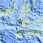
| Location | 0.917°S, 126.801°E |
| Depth | 22 km (13.7 miles) |
| Region | MOLUCCA SEA |
| Distances | 199 km (123 miles) SSW of Ternate, Moluccas, Indonesia 343 km (213 miles) NNW of Ambon, Moluccas, Indonesia 855 km (531 miles) N of DILI, Timor-Leste 1352 km (840 miles) NNW of DARWIN, Northern Territory, Australia |
| Location Uncertainty | horizontal +/- 14.3 km (8.9 miles); depth +/- 9 km (5.6 miles) |
| Parameters | NST= 55, Nph= 57, Dmin=197 km, Rmss=0.92 sec, Gp= 68°, M-type=body wave magnitude (Mb), Version=6 |
| Source |
|
| Event ID | usc0007npd |
- Did you feel it? Report shaking and damage at your location. You can also view a map displaying accumulated data from your report and others.

Earthquake Maps


Scientific & Technical Information
 Historic Moment Tensor Solutions
- Preliminary Earthquake Report
- U.S. Geological Survey, National Earthquake Information Center:
World Data Center for Seismology, Denver
