
Magnitude 4.9 - OFF WEST COAST OF THE SOUTH ISLAND, N.Z.
2012 January 19 12:46:48 UTC
Earthquake Details
- This event has been reviewed by a seismologist.
| Magnitude | 4.9 |
|---|---|
| Date-Time |
|
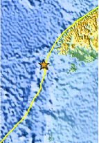
| Location | 46.791°S, 165.542°E |
| Depth | 9.7 km (6.0 miles) |
| Region | OFF WEST COAST OF THE SOUTH ISLAND, N.Z. |
| Distances | 219 km (136 miles) WSW of Invercargill, New Zealand 311 km (193 miles) SW of Queenstown, New Zealand 396 km (246 miles) WSW of Dunedin, New Zealand 958 km (595 miles) SW of WELLINGTON, New Zealand |
| Location Uncertainty | horizontal +/- 14.3 km (8.9 miles); depth +/- 2.5 km (1.6 miles) |
| Parameters | NST= 45, Nph= 46, Dmin=111.3 km, Rmss=0.96 sec, Gp= 90°, M-type=body wave magnitude (Mb), Version=3 |
| Source |
|
| Event ID | usc0007nml |
- Did you feel it? Report shaking and damage at your location. You can also view a map displaying accumulated data from your report and others.
Earthquake Maps


Scientific & Technical Information
 Historic Moment Tensor Solutions
- Preliminary Earthquake Report
- U.S. Geological Survey, National Earthquake Information Center:
World Data Center for Seismology, Denver
