
Magnitude 5.9 - OFF WEST COAST OF THE SOUTH ISLAND, N.Z.
2012 January 19 06:48:48 UTC
Earthquake Details
- This event has been reviewed by a seismologist.
| Magnitude | 5.9 |
|---|---|
| Date-Time |
|
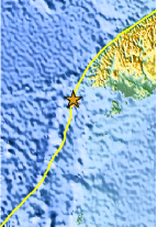
| Location | 46.676°S, 165.724°E |
| Depth | 18.1 km (11.2 miles) |
| Region | OFF WEST COAST OF THE SOUTH ISLAND, N.Z. |
| Distances | 204 km (126 miles) W of Invercargill, New Zealand 293 km (182 miles) SW of Queenstown, New Zealand 380 km (236 miles) WSW of Dunedin, New Zealand 940 km (584 miles) SW of WELLINGTON, New Zealand |
| Location Uncertainty | horizontal +/- 22.5 km (14.0 miles); depth +/- 8.8 km (5.5 miles) |
| Parameters | NST= 45, Nph= 45, Dmin=92.4 km, Rmss=0.78 sec, Gp=108°, M-type=teleseismic moment magnitude (Mw), Version=7 |
| Source |
|
| Event ID | usc0007ng0 |
- Did you feel it? Report shaking and damage at your location. You can also view a map displaying accumulated data from your report and others.
Earthquake Maps


Scientific & Technical Information

 Tsunami Information
The earthquake locations and magnitudes cited in NOAA tsunami statements and bulletins are preliminary and are superseded by USGS locations and magnitudes computed using more extensive data sets.
General Tsunami Information
- Preliminary Earthquake Report
- U.S. Geological Survey, National Earthquake Information Center:
World Data Center for Seismology, Denver
